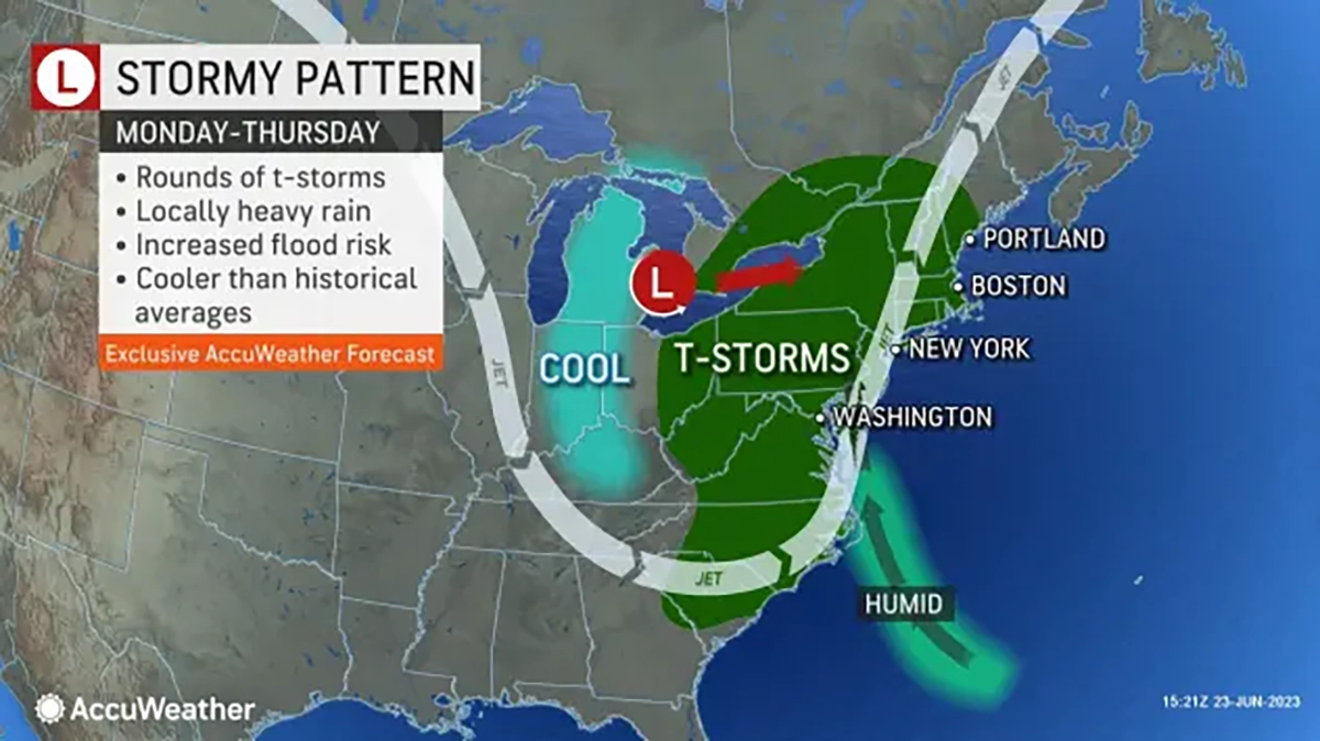
AccuWeather Global Weather Center – June 23, 2022 – An area from the Upper Midwest to the Northeast is bracing for a prolonged period of severe weather threats, as well as damp conditions, according to AccuWeather meteorologists. This stormy pattern, characterized by frequent storms and heavy rainfall, is expected to continue into next week, impacting outdoor plans and potentially causing localized flooding.
AccuWeather Senior Meteorologist Dean DeVore states, “Over the last few months, the Northeast and Great Lakes weather has taken dramatic turns, from warm and wet to dry and smoky. As we head into the first weekend of astronomical summer, the pattern will flip to humid and active weather with showers and occasional thunderstorms. This pattern looks like it lasts well into next week.”
The storm responsible, which has already brought significant rainfall to the Southeast, is projected to move northeastward through New England on Saturday. As it progresses, thunderstorms are likely to develop along associated frontal boundaries, increasing the risk of localized flooding.
For the latest information, click HERE
Residents across the Northeast will also experience rising dew points, indicating higher humidity levels. AccuWeather Senior Meteorologist Dan Pydynowski explains, “A more sustained pattern of higher humidity is in place across the Northeast, Great Lakes, mid-Atlantic, and Ohio Valley. The Gulf of Mexico will finally be open to the eastern half of the nation as a prolonged southerly flow allows tropical moisture to flow northward.”
Dew points are expected to reach the upper 60s and even lower 70s degrees Fahrenheit over the weekend and early next week. These elevated levels of moisture may lead to discomfort for some Northeast residents. Relief from the humidity is not expected until the middle to latter half of next week when a secondary storm from the Midwest passes through the interior Northeast.
AccuWeather Meteorologist Brandon Buckingham warns, “Another storm early next week will keep the wet regime in place. This turn toward very active weather could produce localized areas of above-average rainfall for the month of June.”
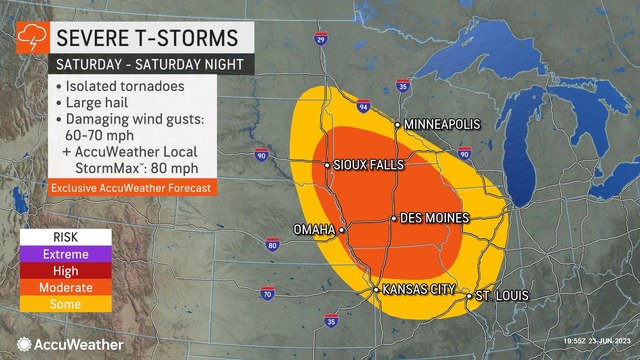
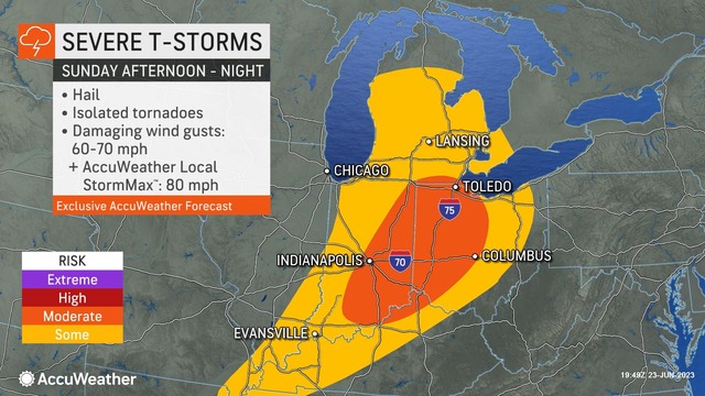
Furthermore, the approaching secondary storm is anticipated to trigger severe thunderstorms across the Plains before moving into the Great Lakes region on Sunday. Subsequently, the threat of strong to severe thunderstorms will shift to portions of the Ohio Valley, including central Michigan, Indiana, southeastern Illinois, western and northern Kentucky, and Ohio. These areas may experience storms capable of producing hail, damaging wind gusts, and isolated tornadoes.
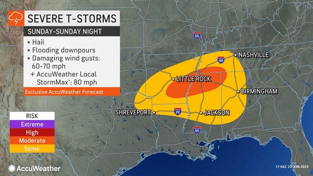
There will also be the potential for severe thunderstorms from northeastern Texas into the Tennessee Valley and central Gulf Coast states Sunday, with the potential for flash flooding, damaging winds, and hail.
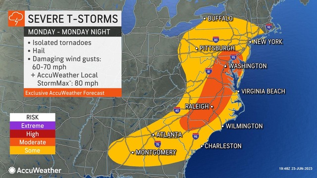
On Monday, the severe weather threat will extend eastward as the parent storm advances into the Northeast. Strong thunderstorms with gusty winds reaching 60-70 mph and the potential for isolated tornadoes are expected from Pennsylvania down to the Carolinas and the Gulf Coast.
The combination of moisture from the South and frontal boundaries moving across the region will contribute to drenching thunderstorms with the potential for heavy rainfall. Motorists are advised to exercise caution as downpours can reduce visibility and lead to rapidly developing standing water and ponding on roadways.
Despite the risks associated with these storms, the damp weather will offer some relief to the mid-Atlantic region, which has been grappling with moderate to severe drought conditions. The rain over the next few days may prove beneficial in alleviating the current drought situation.
Following the passage of rain and thunderstorms, a brief cooldown is expected as cooler air from Canada sweeps into the region. Some areas, including Columbus, Ohio, and Charleston, West Virginia, can anticipate temperatures dipping into the lower 70s F from Tuesday to Wednesday.
Read this story in its original context at AccuWeather.com.