
PLUS: Comprehensive coverage from AccuWeather (below)
Hey, Greylock Nation. As we look ahead, our region is gearing up for a dynamic mix of weather conditions. Starting tonight, we’ll see partly cloudy skies with temperatures dipping to the low 20s. But don’t get too comfy — the weather’s about to shift gears.
Tuesday brings a combo of rain and snow, with winds picking up speed throughout the day. Expect variable conditions, from light flurries to gusty winds, as temperatures fluctuate around the mid-30s. Tuesday night, the scenario intensifies with heavy rain, potent winds, and a possible mix of sleet and snow. The thermometer might even hit the high 40s by dawn on Wednesday.
Heading into Wednesday, rain remains likely, especially in the morning, with brisk winds and temperatures hovering near 50 degrees. It’s a classic case of early January’s unpredictable moods.
Now, let’s break down the specific weather advisories to keep you informed and prepared.
Flood Watch Alert
When: Tuesday evening through Wednesday afternoon
Where: Northern and Southern Litchfield (CT), Northern and Southern Berkshire (MA), and parts of East Central NY, including areas near Albany, Rensselaer, and Ulster. Yes, that means you, Pittsfield and North Adams folks!
What’s Happening: Expect a real mash-up of heavy rain and snowmelt. That snowpack we’ve been chilling on? It’s about to get a whole lot less chill. Rivers and streams might just decide to break their banks and visit your backyard.
Be Prepared: If you’re in a flood-prone area, keep an eye out and be ready to move to higher ground. Check out more details at National Weather Service Flood Safety.
Winter Weather Advisory in Northern Berkshire
When: 3 PM Tuesday to midnight Tuesday night
What to Expect: Snow, then a bit of an icy encore, followed by rain. Snow accumulations of 2 to 5 inches, light ice, and wind gusts up to 60 mph. Yep, it’s going to be one of those days.
Where: This one’s especially for you, Dalton, Hancock, Pittsfield, Florida, and North Adams.
Impact: Slippery roads and potential evening commute chaos. Those winds could also play games with trees and power lines.
Advice: Slow down, be cautious, and maybe it’s a good night to stay in with some hot cocoa.
High Wind Warning! Hold Onto Your Hats!
When: 4 PM Tuesday to 7 AM Wednesday
Where: Northern and Southern Berkshire (MA), and parts of Herkimer, Hamilton, Rensselaer, and Columbia Counties in NY, plus Bennington (VT).
What’s Happening: Southeast winds going wild at 30-40 mph, with gusts up to a whopping 60 mph.
Impact: Expect some tree and power line dance-offs, leading to possible power outages. High profile vehicles might find the journey tough.
Safety Tip: Stay away from forested areas and those moody trees and branches. If you can, stay indoors and away from windows during the worst of it.
Stay Safe, Stay Informed!
Remember, folks, better safe than sorry. Keep up with the latest updates, and let’s all weather this weather together!
Comprehensive coverage from AccuWeather
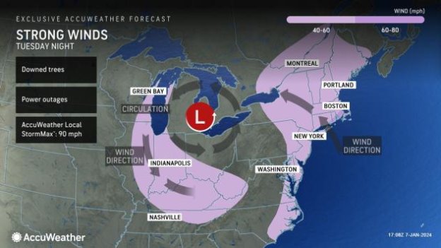
AccuWeather Global Weather Center – January 8, 2024 – Less than three days on the heels of a storm that brought heavy snow over the interior Northeast and drenching rain on the mid-Atlantic coast, a stronger, larger and warmer storm will eye the region with major impacts, power and travel disruptions and potentially dangerous conditions from high winds and flooding from Tuesday to Wednesday, AccuWeather meteorologists warn.
A large and furious storm will take shape over the Central states from Monday to Tuesday. As this storm tracks from the southern Plains to the Great Lakes, its massive and strengthening circulation will pull in much warmer air from the Gulf of Mexico and the Atlantic Ocean on powerful south-to-southeast winds from Tuesday afternoon through Tuesday night.
In areas where there is snow on the ground in the Northeast, a rapid thaw will occur.
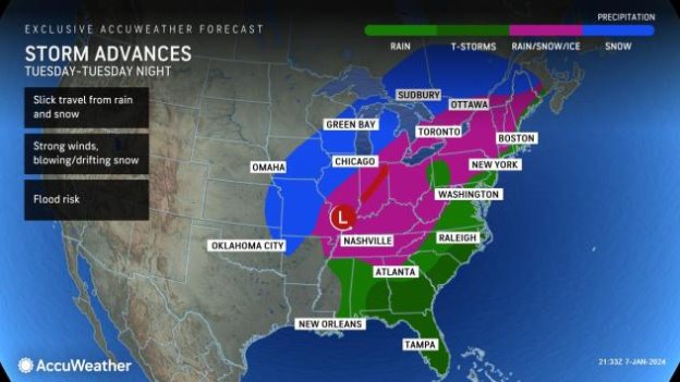
“Initially, the storm is likely to bring a burst of heavy snow and perhaps a period of ice or wintry mix across parts of the central Appalachians and New England for a time on Tuesday,” AccuWeather Senior Meteorologist Dan Pydynowski said, adding, “But, the most notable impact from the upcoming storm will be high winds and flooding rainfall.”
From AccuWeather Chief Meteorologist Jon Porter: “AccuWeather meteorologists are increasingly concerned about the risk of significant flooding across parts of the Northeast starting on Tuesday. Several factors can conspire to produce a dangerous setup including the potential for several inches of rainfall, rapid snowmelt and already water-logged soil. Flash flooding may be the first impact followed by creek and stream flooding and, over time, river flooding. We recommend people in the East to frequently check the AccuWeather forecast over the coming days to stay updated on the flooding threat.”
Porter also said “there is also risk for some of the most intense flash flooding to occur at night on Tuesday night, which is especially concerning because people generally have less awareness of what is going on around them after dark, especially related to water overtopping roadways, which can quickly result in a life-threatening flooding emergency.”
“Some people in and near the I-95 corridor in the Mid-Atlantic and Northeast may have difficulty in getting to work, school or other commitments on Wednesday morning due to the flooding and as well as downed trees and power lines blocking some roads, Porter commented.
Porter also shared that “people who live in low-lying or other flood prone areas and along creeks, streams, rivers and other waterways will want to be especially vigilant about the flooding risk and consider taking precautions such as moving property out of the floor of basements which may flood and deploying sandbags in the proper location at your home or business to reduce the risk of flooding. Watch for and avoid rapidly rising water – especially while driving.”
Gusts frequenting 40-60 mph with an AccuWeather Local StormMax™ wind gust near 75 mph will raise the risk of regional power outages.
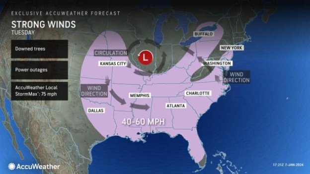
The strongest winds will be along the Atlantic coast and over the ridges of the Appalachians. Tree and property damage are likely. Large tree limbs may come crashing down on sidewalks, vehicles, homes and businesses without notice. Trash cans and other unsecured items in neighborhoods may become projectiles.
Power outages could be long-lasting, especially in remote, heavily wooded areas.
Dangerous rapid meltdown, flood event may ensue
The storm will gather a great deal of moisture from the Gulf of Mexico and the Atlantic quickly and wring that moisture out over the mid-Atlantic and New England.
“A general 1-3 inches of rain alone that falls on the saturated ground from prior storms back through December is enough to lead to rapid flooding in poor drainage areas and along small streams,” Pydynowski stated.
Since much of the rain coming from the storm from Tuesday to Wednesday may occur in a matter of several hours and will be combined with melting snow, many streams and rivers will rise extremely fast and flood unprotected areas with little notice, Pydynowski warned.
While there will be much less snow on the ground when compared to early January 1996, there is the potential for a rapid meltdown and flooding event similar to what occurred in the region nearly 27 years ago.
Property owners and township supervisors in the Northeast are urged to closely monitor the flood potential with this weekend’s storm, and especially that from the powerful storm spanning Tuesday to Wednesday. The sudden rush of water down mountainsides into the valleys could lead to some roads becoming blocked with debris or washed out. The flash flooding could be so significant that it may also pose a threat to lives in extreme cases.
The same storm system will lead to drought relief in the Southeast, but also the likelihood of flooding and severe thunderstorms from Monday to Tuesday.
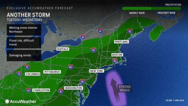
Yet another storm could bring a surge of mild air and more rain to the region during the second weekend of January, resulting in a resurgence of high water and flooding problems in the Northeast.
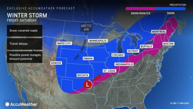
That storm can potentially bring blizzard conditions to multiple states in the Midwest from Friday, Jan. 12, to Saturday, Jan. 13., as the first major outbreak of Arctic air of the winter reaches from the Midwest to the Central states.
Additional AccuWeather Resources:
Northeast may face rapid meltdown, major flooding and damaging winds from trailing storm
Massive winter storm to blast more than 30 states with snow, rain or wind
Robust thunderstorms to bring nocturnal tornado threat to the Gulf Coast early week